VALAR WATCHTake action

Maps

Where each site is, and how big, on maps drawn from official boundary data.

Every outline is drawn from official boundary data: the BLM survey grid, county parcel maps compiled by the state, and BLM's own case map. They are accurate to the tens of meters those datasets carry; they are not a legal survey. Basemap: USGS The National Map (public domain). Tap a map for full size.

Every project

Ward 250 test reactor
State lab, 800 N Coal Haul Rd, Orangeville (Emery County) · Fenced area about 2 acres, on a 20.6-acre state lab

DOE-authorized; reached zero-power criticality June 18, 2026; its safety papers describe a 12-month test.

The parcel beside the lab approved for sale to Valar
Emery County parcel 04-0019-0030, next to the state lab · About 112 acres

Emery County approved selling it to Valar for $394,500 (records disagree on whether the sale closed); Valar told the county it wants it for fuel fabrication and manufacturing; Orangeville is drafting a zone to annex it.

Wellington lease (the Carbon County campus)
Section 16, T14S R11E, about five miles north of Wellington · 480 acres of state trust land approved; the other 160 if the Utah National Guard lease is moved

Lease approved Sept 17, 2026 for a nuclear, fuel and industrial campus, up to a century, with the right to buy; nothing built; no county permit application found.

RW 453 lode mining claim
North half of Section 28, T14S R11E, about two miles south of the lease · One lode claim is at most about 1,500 by 600 feet (about 20.7 acres)

A Notice of Location dated Sept 12 names Valar as locator; the land is zoned rural residential; the county copy is due about Oct 12 and the BLM filing by Dec 11.

'Green River Gigasite' application
BLM land northwest of Green River (Emery County) · 10,270 acres in BLM's case record

Pending with BLM as of late September 2026; Valar told a reporter it applied for survey access and has decided not to pursue it.

'Project Beehive' application
North of Wellington and Price: the outline on the region map is traced from NPR's 30 September 2026 map (approximate). BLM's public records show no location. · About 9,700 acres as NPR mapped it, including the state lease section; NPR reported over 9,000 acres of BLM land

A second pending BLM application by Valar for a reactor and data-center site; BLM's public records show no location for it.

'Jurassic Spark' technology park (no Valar link found)
Sections 36 and 2, east of Wellington along U.S. 6 · About 1,240 private acres

Altigen JS, LLC's permit is before the Carbon County Planning Commission on Oct 6; the developer's stated plan is gas-fired power plants; no record links it to Valar.

The maps

The region: Valar's sites and proposals in Carbon and Emery counties, Project Beehive, and nearby state permit applications
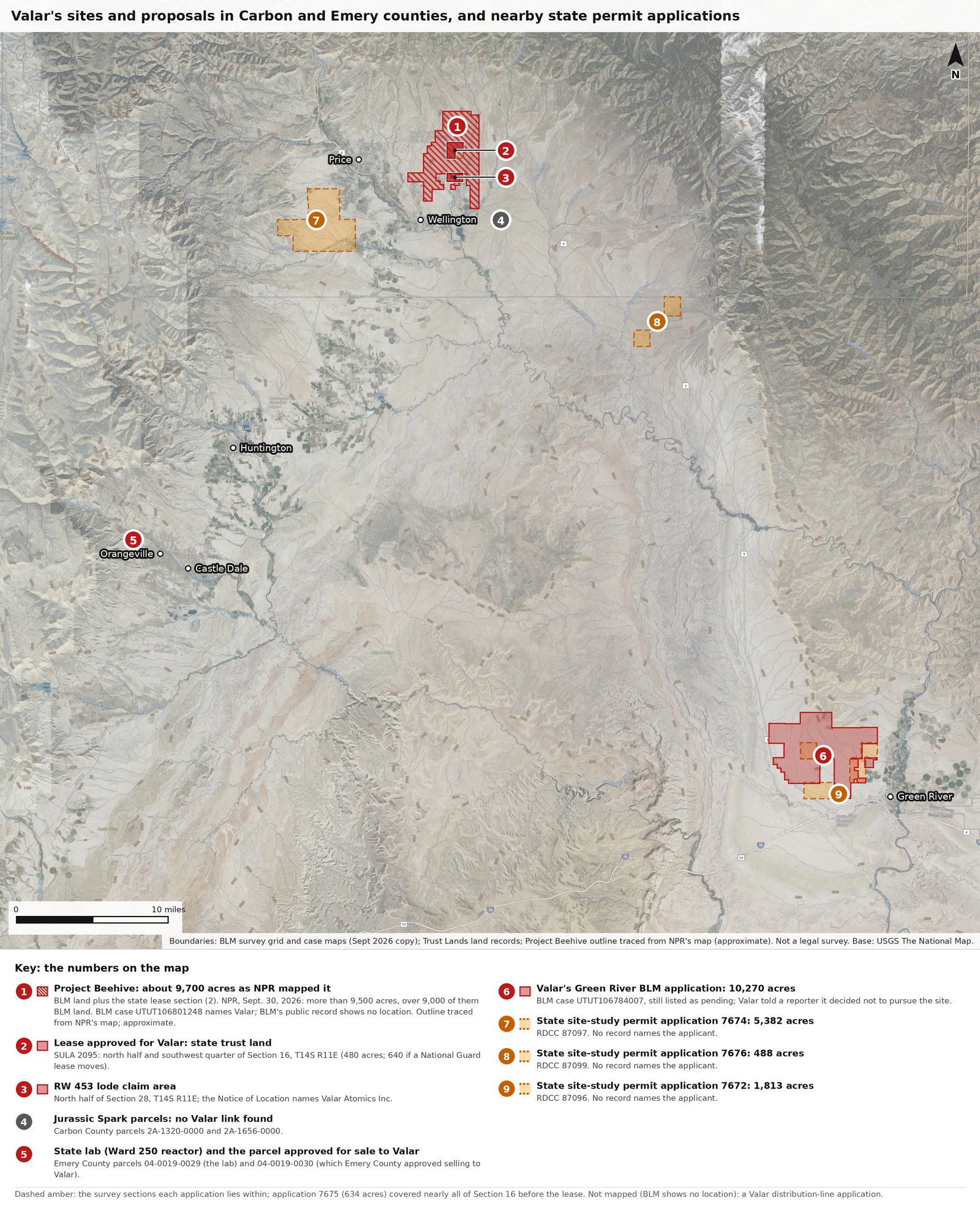
The region: Valar's sites and proposals in Carbon and Emery counties, Project Beehive, and nearby state permit applications
The numbers on the map match the key printed under it. 1: Project Beehive. Its outline is traced from the map in NPR's report of 30 September 2026 and squared to the survey grid, so it is approximate: about 9,700 acres as drawn, BLM land plus the state lease section. NPR reported over 9,000 acres of BLM land. BLM's public case record, UTUT106801248, names Valar but shows no location. 2: the lease approved for Valar, SULA 2095 (the north half and southwest quarter of Section 16, T14S R11E, 480 acres). 3: the RW 453 claim area (the north half of Section 28, T14S R11E). 4: Carbon County parcels 2A-1320-0000 and 2A-1656-0000, the Jurassic Spark site (no Valar link found). 5: Emery County parcels 04-0019-0029 (the state lab) and 04-0019-0030 (the parcel approved for sale to Valar). 6: BLM case UTUT106784007 at Green River (BLM still lists it as pending; Valar told a reporter it decided not to pursue the site). 7 to 9: three applications for state site-study permits posted in February (7674, 7676 and 7672; state project-register numbers RDCC 87097, 87099 and 87096), drawn as the survey sections each lies within. No record names their applicant or shows the permits were issued. A fourth application, 7675, covered nearly all of the lease section. Sources: plan-017, mine-011, mine-453, dir-015, gov-022, mine-006, mine-008, dir-035, dir-036, dir-037

Around Price and Wellington: Project Beehive, Valar's sites and a nearby state permit application
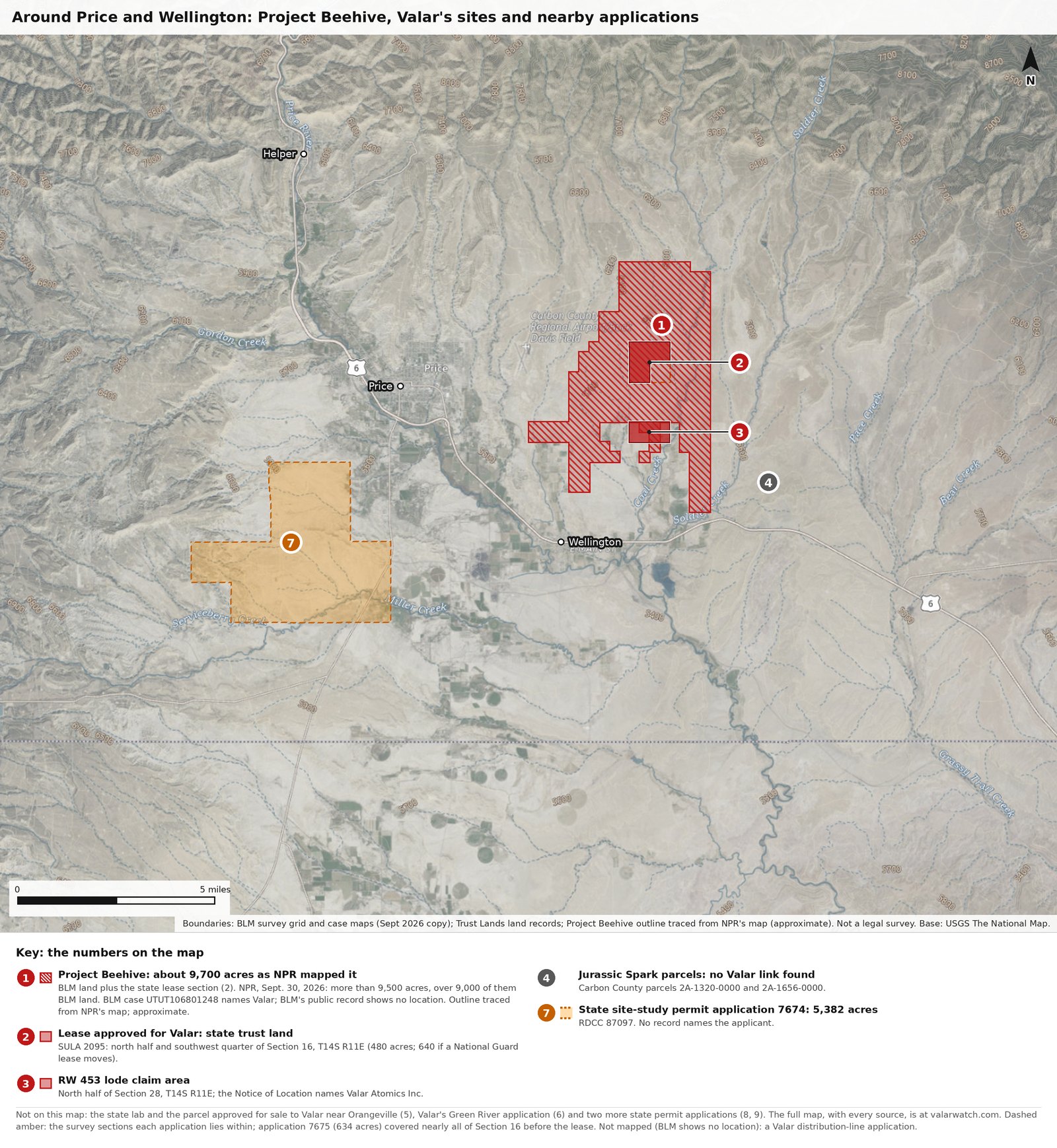
Around Price and Wellington: Project Beehive, Valar's sites and a nearby state permit application
The same outlines and numbers as the region map, closer in: 1, Project Beehive (outline traced from the map in NPR's report of 30 September 2026, approximate); 2, the lease approved for Valar, SULA 2095; 3, the RW 453 claim area; 4, the Jurassic Spark parcels (no Valar link found); 7, state site-study permit application 7674 (no record names its applicant). This is the map printed on the handout. Sources: plan-017, mine-011, mine-453, dir-015, dir-037

North and east of Wellington: the lease approved for Valar, the RW 453 claim area, and the Jurassic Spark site
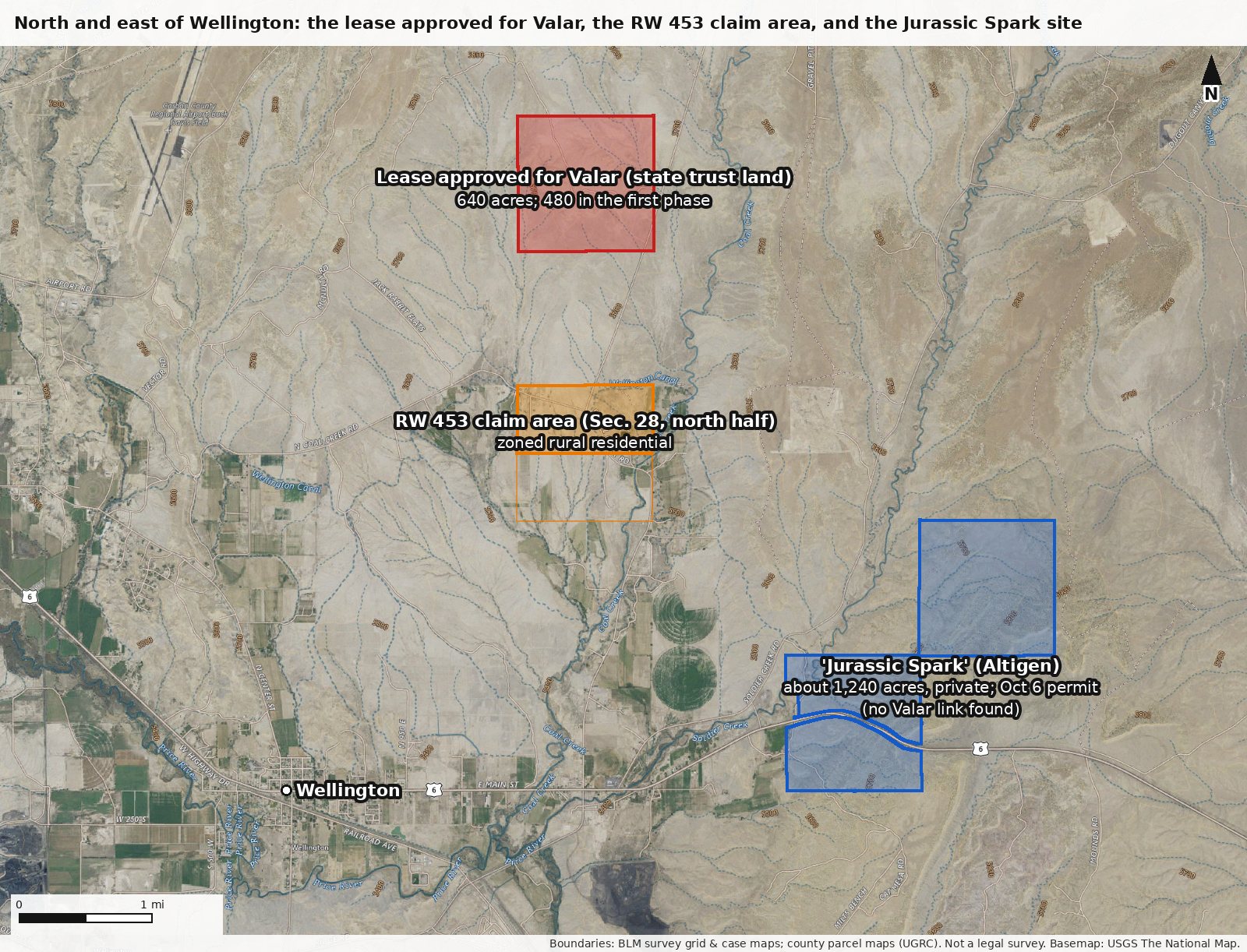
North and east of Wellington: the lease approved for Valar, the RW 453 claim area, and the Jurassic Spark site
Red: Section 16, T14S R11E, the state school trust land the Trust Lands board approved leasing to Valar on September 17, 2026 (480 acres approved, 640 if the Utah National Guard lease is moved; no signed lease found yet), zoned Mining & Grazing. Orange: the north half of Section 28, where a Notice of Location places Valar's RW 453 lode claim; the claim itself, about 1,500 by 600 feet, cannot be placed more exactly from the notice; this land is zoned rural residential. Blue: the two private parcels, about 1,240 acres, in the 'Jurassic Spark' technology-park permit before the Planning Commission on October 6; no record links that project to Valar. Sources: mine-011, csite-001, mine-453, dir-001, dir-013, dir-015, plan-017

Orangeville: the state lab that hosts Ward 250, and the land next to it approved for sale to Valar
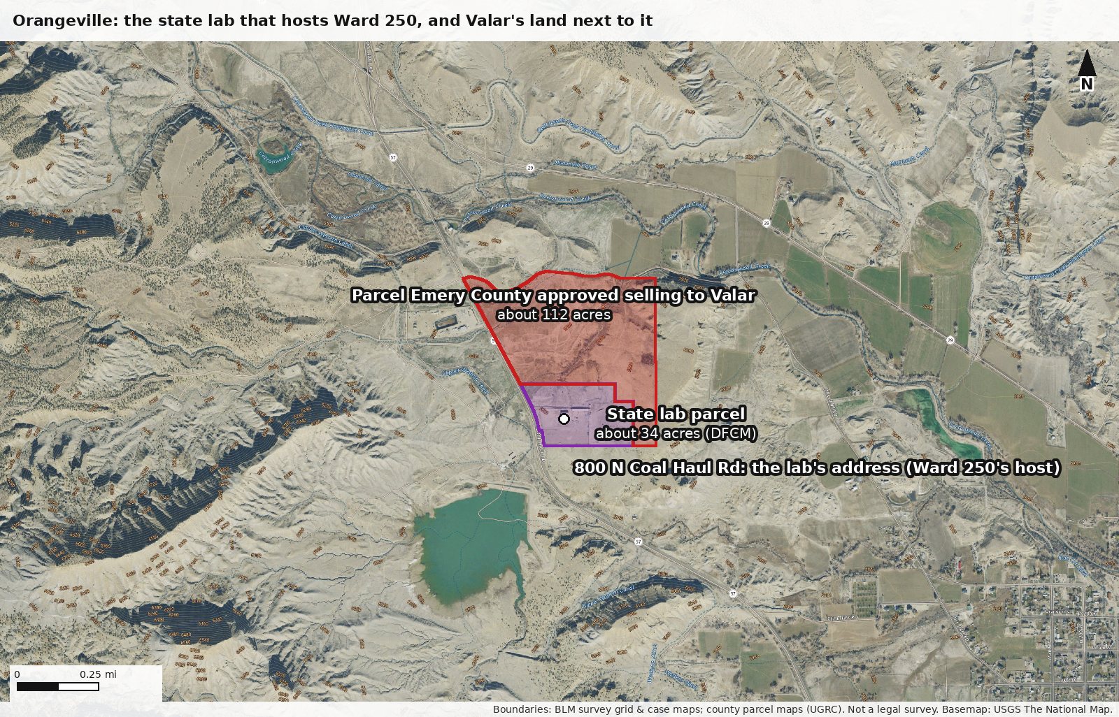
Orangeville: the state lab that hosts Ward 250, and the land next to it approved for sale to Valar
Purple: the state-owned parcel (Utah DFCM, about 34 acres) that holds the lab's address, 800 N Coal Haul Rd, where Ward 250 operates; DOE's review describes the lab as a 20.6-acre site, with the reactor inside a fenced area of about 2 acres. Red: Emery County parcel 04-0019-0030, about 112 acres, which the county approved selling to Valar for $394,500; the records disagree on whether the sale has closed. The accident analysis assumes the public stays 400 meters from the reactor; at this map's scale that is a little under a quarter mile. Sources: safe-014, gov-022, mine-018, loc-014

Near Green River: Valar's pending BLM application for a reactor and data-center site
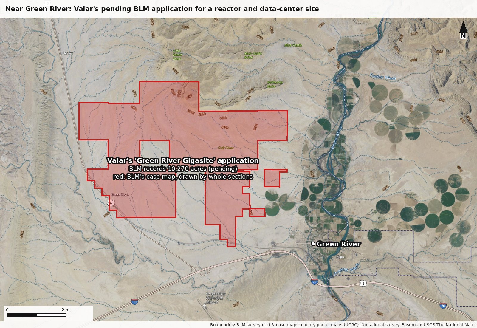
Near Green River: Valar's pending BLM application for a reactor and data-center site
Red: BLM case UTUT106784007, 'Green River Gigasite Small Modular Reactor/Data Center', drawn from BLM's own case map, which shades whole sections: it covers all of Sections 20 and 21 (T20S R15E), where the application lists only their southern strips, so the red area (about 13,400 acres) is larger than the land listed. The unshaded square inside is Section 32, which the application leaves out. BLM's record lists 10,270.61 acres, still pending in late September 2026. Valar told a reporter it applied for survey access and has decided not to pursue the site. Sources: mine-006, mine-007, mine-008